Jammu And Kashmir
Jammu And Kashmir
Shankaracharya hill in srinagar is a famous tourist attraction
most beautiful mughal gardens
Overlooked by the Zabarwan Mountain
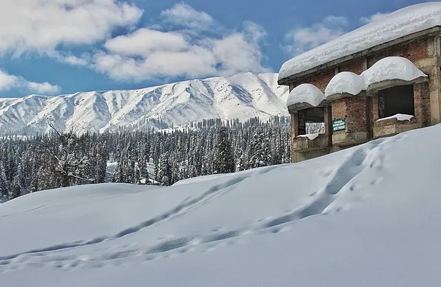
Sonmarg is a hill station
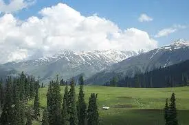
Beautiful Gulmarg
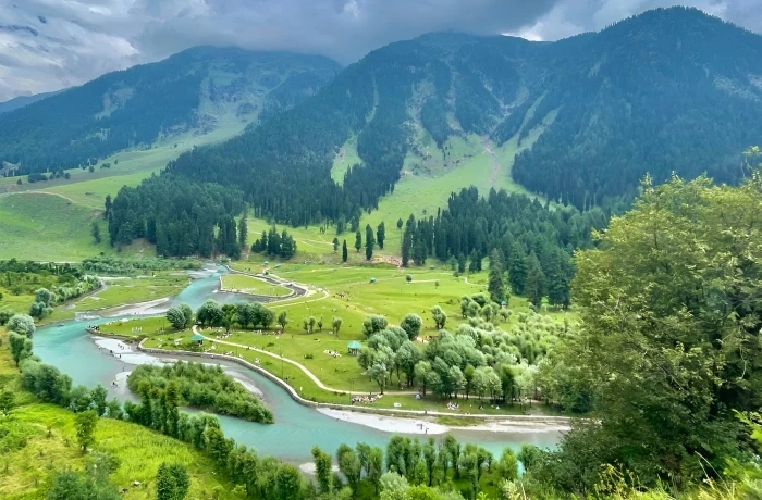
Pahalgam is a tourist town.
- includes
- excludes
Things to do in and around jammu_and_kashmir
How to reach jammu_and_kashmir?
We've established convenient pickup and drop options right in your vicinity. Simply download the app, book your package using your location, and inform us of your exact whereabouts. Additionally, we've outlined various routes to reach the destination, taking into account commonly used traffic patterns.
Additional Information about Jammu And Kashmir
Jammu And Kashmir For enquiries
If you are looking to know more information about Jammu And Kashmir, our team at jammu_and_kashmir will assist you personally through the below dedicated number
Jammu And Kashmir address
Jammu And Kashmir,
jammu_and_kashmir,
jammu_and_kashmir
Whatsplan's Jammu And Kashmir contact number : +91 9842067265
Places covered in(14)
Thajiwas Glacierganderbal, jammu_and_kashmir
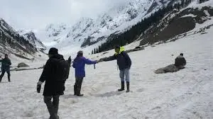
The Thajiwas Glacier is located 3 kilometers from town. It would not be wrong to consider it to be among the most accessible glaciers as one can easily walk to its base or reach there by hired ponies. The Thajiwas Glacier recedes as the summer progresses. By the time of my trip, it had dwindled in the vast valley and was confined to the gentle slopes, where the mountain begins. Sonmarg (translation: "Meadow of Gold") is a hill station in Ganderbal district in the Indian state of Jammu and Kashmir about 80 km north-east of Srinagar.
Pahalgamsrinagar, jammu_and_kashmir
Pahalgam is a tourist town and a notified area committee in Anantnag district of the Indian state of Jammu and Kashmir. It is a popular tourist destination and hill station. Its lush green meadows and pristine waters attract thousands of tourists from all over the world each year. It is located 45 kilometres (28 mi) from Anantnag on the banks of Lidder River at an altitude of 7,200 feet (2,200 m). Pahalgam is the headquarters of one of the five tehsils of Anantnag district. Pahalgam is associated with the annual Amarnath Yatra. Chandanwari, located 16 kilometres (9.9 mi) from Pahalgam is the starting point of the yatra that takes place every year in the months of July–August.
Awantiporapulwama, jammu_and_kashmir
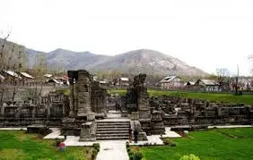
Awantipora or Awantipur is a town and a notified area committee in Pulwama district of the Indian state of Jammu & Kashmir. It is situated between Anantnag and Srinagar on NH 44 (former name NH 1A before renumbering of all national highways). Awantipora was named after Avanti Varman and had a number of ancient Hindu temples built by the king including the Avantiswami Temple. The ruins of temples constructed by Lalitaditya are also found in Awantipora. The temple sites are protected and maintained by the Archaeological Survey of India.
Zabarwan Rangesrinagar, jammu_and_kashmir

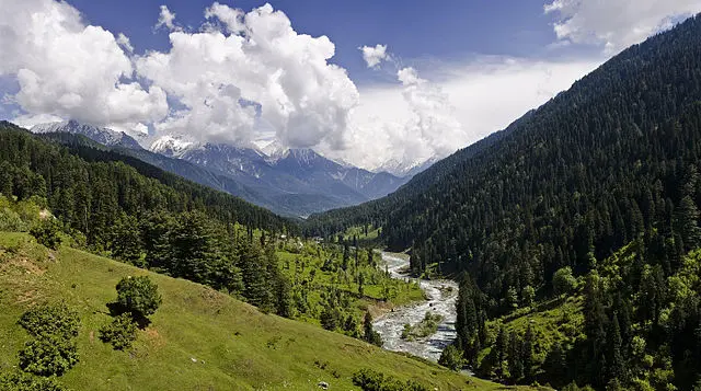
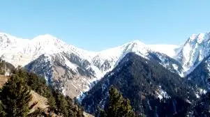
The Zabarwan Range is a short (20 mi (32 km) long) sub-mountain range between Pir Panjal and Great Himalayan Range in the central part of the Kashmir Valley in the state of Jammu and Kashmir in India. The Zabarwan Range borders the central part of the Kashmir Valley in the east. Literally it is the mountain range between Sind Valley and Lidder Valley on the north and south, and between the Zanskar Range and Jehlum Valley on the east and west, respectively.[3] Specifically the range is known to be what overlooks the Dal Lake and holds the Mughal gardens of Srinagar. The north end of the range lies in Ganderbal, while the south end lies in Pampore. The Shankaracharya Temple is built on the edge of the central part of the Zabarwan Range. The highest peak of this range is Mahadev Peak at 13,013 feet (3,966 m), which forms the distant background of the eastern mountain wall. On the northern slopes of the central part of the range there are three Mughal gardens built by Emperor Shah Jahan. These include Chashma Shahi, Nishat Bagh and Shalimar Garden alongside the Pari Mahal (the fairy palace). The recently built Indira Gandhi Memorial Tulip Garden in the lap of the Zabarwans is considered the largest tulip garden of Asia spread over 12 hectares of land. The Zabarwan mountain range possesses great Himalayan features with rich wildlife. The Dachigam National Park, spread over 141 km2, is the main feature of the range. The Dachigam National Park holds the last viable population of Kashmir stag (Hangul) and the largest population of black bear in Asia. The range is also home to musk deer, leopard, Himalayan brown bear, leopard cat, jungle cat, red fox, jackal, Himalayan wolf, serow, Himalayan yellow-throated marten, long-tailed marmot, Indian porcupine, Himalayan mouse-hare, langur and Himalayan weasel. The climate of the Zabarwans can be summed up from the climate of Dachigam. It is a sub-Mediterranean type, with two spells of dryness from April to June and September to November. The range has irregular weather conditions with a considerable variation in the amount of precipitation. Snow is the main source of precipitation, and in some parts melts till June.
Shankaracharya Templesrinagar, jammu_and_kashmir
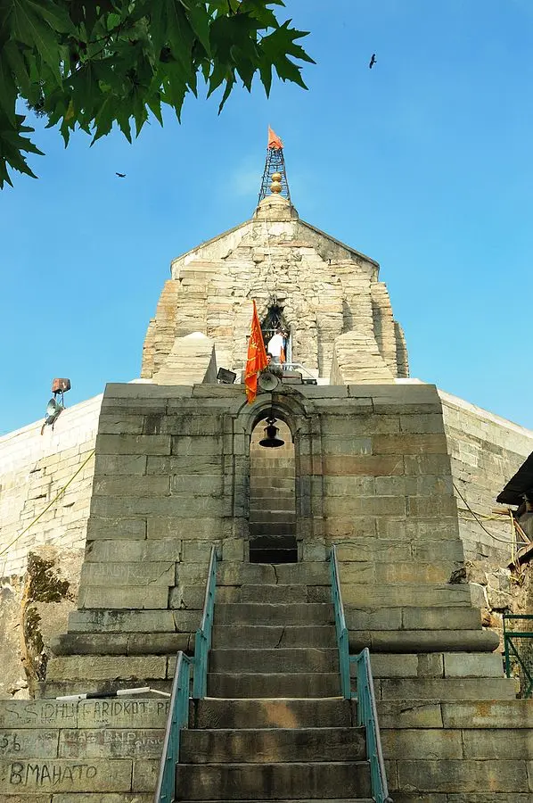
The Shankaracharya Temple is also known as the Jyeshteshwara temple or Sulaiman Throne (Takht e Sulaiman) by Muslims and Pas Pahar by Buddhists. It is on top of the Shankaracharya Hill on the Zabarwan Mountain in Srinagar, Jammu and Kashmir, India. It is dedicated to Lord Shiva (Shri Shiv Ji). The temple is at a height of 1,000 feet (300 m) above the plain and overlooks the city of Srinagar. The temple dates to 200 BC, although the present structure probably dates to the 9th century AD. It was visited by Adi Shankara and has ever since been associated with him; this is how the temple got the name Shankaracharya. It is also regarded as sacred by Buddhists. Some historians report that the temple was actually a Buddhist temple during the Buddhist era which was then changed into Hindu site of worship by Adi Shankaracharya. Persians and Jews call it Bagh-i-sulaiman or the Garden of King Solomon. Persian inscriptions are also found inside the temple. Kashmir is believed to be the seat of Shaivam, the Himalaya Mountains and Sri Kailashagiri as "The massed laughter of Sri Shiva." It was from here that the sweet nectar of Shiva devotion spread in India and around the globe, by the spiritual works of saints like Adi Shankaracharya. Soundarya Lahari was composed by Adi Shankara atop the Gopadari Hill, after accepting the fact that the union of Sri Shiva and Devi Shakti, as in Shaktism, transpired into the Shakti-Shri Chakra, the symbol of Devi (Goddess), as Sri Yantra, as mentioned in 'Shankara Digvijay' - Life history of Shankaracharya, and only when Shiva is united with Shakti does he have the power to create.
Sonamarg ganderbal, jammu_and_kashmir
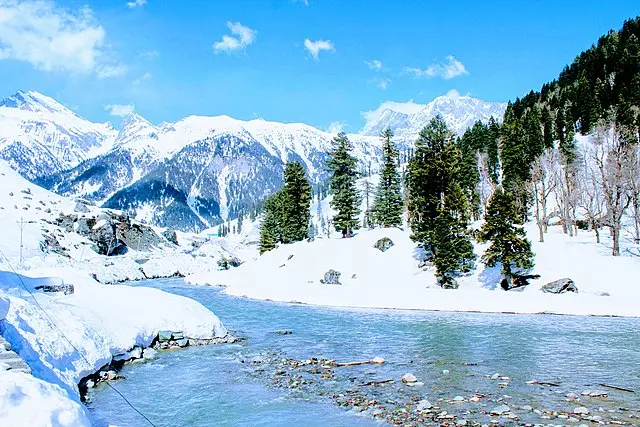
Sonmarg is a hill station in Ganderbal district in the Indian state of Jammu and Kashmir about 80 km north-east of Srinagar. Sonamarg is a commercial tourist destination and it’s one of the places where you will find more tourists than locals during the season.
Pir Panjal Rangesrinagar, jammu_and_kashmir
The Pir Panjal Range is a group of mountains in the Inner Himalayan region, running from east-southeast (ESE) to west-northwest (WNW) across the Indian states of Himachal Pradesh and Jammu and Kashmir where the average elevation varies from 1,400 m (4,600 ft) to 4,100 m (13,500 ft). The Himalayas show a gradual elevation towards the Dhauldhar and Pir Panjal ranges. Pir Panjal is the largest range of the lower Himalayas. Near the bank of the Sutlej river, it dissociates itself from the Himalayas and forms a divide between the rivers Beas and Ravi on one side and the Chenab on the other. The renowned Galyat mountains are also located in this range. The Pir Panjal range is named after the Pir Panjal Pass, whose original name as recorded by Srivara, is Panchaladeva, meaning the deity of Panchala). Panchala is a country mentioned in the Mahabharata in the northwest Uttar Pradesh. However, there are also traditions that place the Mahabharata regions in western Punjab and southern Kashmir. Scholar Dineshchandra Sircar has analysed the geography described in the Shakti‐sangama Tantra, where this is indeed the case. Scholar M. A. Stein believes that the concept of deity must have been translated into that of a Pir after the region was Islamised. Haji Pir Pass (altitude 2,637 m (8,652 ft)) on the western Pir Panjal range on the road between Poonch and Uri is in the area of Kashmir administered by Pakistan. The Pir Panjal Pass (also called Peer Ki Gali ) connects the Kashmir valley with Rajouri and Poonch via the 'Mughal Road'. It is the highest point of Mughal road at 3,490 m (11,450 ft) and lies to the south west of the Kashmir valley. The nearest town to the pass in the Kashmir valley is Shopian, the apple town.
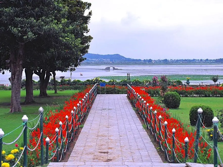
Mughal Gardenssrinagar, srinagar
Mughal gardens are a group of gardens built by the Mughals in the Persian style of architecture. This style was heavily influenced by the Persian gardens particularly the Charbagh structure. Significant use of rectilinear layouts are made within the walled enclosures. Some of the typical features include pools, fountains and canals inside the gardens. The founder of the Mughal empire, Babur, described his favourite type of garden as a charbagh. They use the term bāgh, baug, bageecha or bagicha for garden. This word developed a new meaning in India, as Babur explains; India lacked the fast-flowing streams required for the Central Asian charbagh. The Aram Bagh of Agra is thought to have been the first charbagh in South Asia. India, Bangladesh and Pakistan have a number of Mughal gardens which differ from their Central Asian predecessors with respect to "the highly disciplined geometry". An early textual references about Mughal gardens are found in the memoirs and biographies of the Mughal emperors, including those of Babur, Humayun and Akbar. Later references are found from "the accounts of India" written by various European travellers (Bernier for example). The first serious historical study of Mughal gardens was written by Constance Villiers-Stuart, with the title Gardens of the Great Mughals (1913). Her husband was a Colonel in Britain's Indian army. This gave her a good network of contacts and an opportunity to travel. During their residence at Pinjore Gardens, Mrs. Villiers-Stuart also had an opportunity to direct the maintenance of an important Mughal garden. Her book makes reference to the forthcoming design of a garden in the Government House at New Delhi (now known as Rashtrapati Bhavan). She was consulted by Edwin Lutyens, and this may have influenced his choice of Mughal style for this project. Recent scholarly work on the history of Mughal gardens has been carried out under the auspicious guidance of Dumbarton Oaks (including Mughal Gardens: Sources, Places, Representations, and Prospects edited by James L. Wescoat, Jr. and Joachim Wolschke-Bulmahn) and the Smithsonian Institution. Some examples of Mughal gardens are Shalimar Gardens (Lahore), Lalbagh Fort at Dhaka, and Shalimar Bagh (Srinagar). From the beginnings of the Mughal Empire, the construction of gardens was a beloved imperial pastime.[3] Babur, the first Mughal conqueror-king, had gardens built in Lahore and Dholpur.
Nishat Baghsrinagar, jammu_and_kashmir
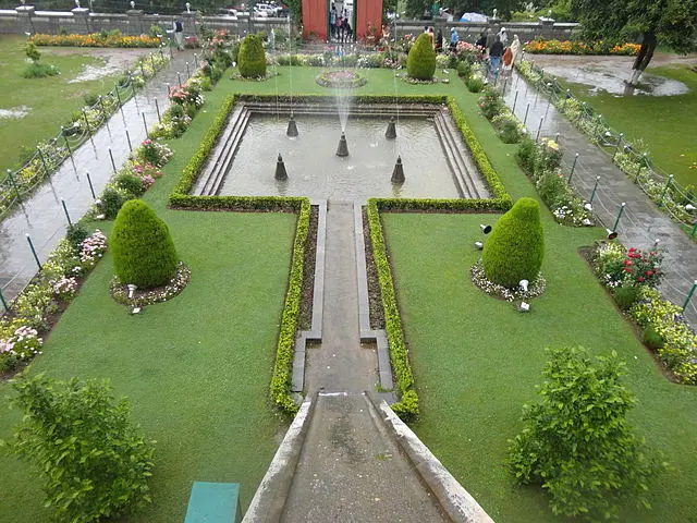
Nishat Bagh is a terraced Mughal garden built on the eastern side of the Dal Lake, close to Srinagar in the state of Jammu and Kashmir, India. It is the largest Mughal garden in the Kashmir Valley . Shalimar Bagh, which is also located on the bank of the Dal Lake. ‘Nishat Bagh’ is Urdu, which means "Garden of Joy," "Garden of Gladness" and "Garden of Delight. Located on the bank of the Dal Lake, with the Zabarwan Mountains as its backdrop, Nishat Bagh is a garden with views of the lake beneath the Pir Panjal mountain range. The Bagh was designed and built in 1633 by Asif Khan, elder brother of Nur Jehan. Even though the layout of Nishat Bagh was based on the basic conceptual model of the Persian gardens, it had to be remodelled to fit the topographic and water source conditions at the site chosen in the Kashmir valley. The plan, instead of being central with four radiating arms in a square pattern as in the case of Chahar (suited for a flat country side), was changed to an axial stream flow design to fit the hill condition with water source originating at the top of the hill end. This resulted in planning a rectangular layout rather than a square layout. This helped in dispensing with the long side arms. Thus, a rectangular layout with east-west length of 548 metres (1,798 ft) and width of338 metres (1,109 ft) was adopted. Thus, Nishat Bagh as laid out now is a broad cascade of terraces lined with avenues of chinar and cypress trees, which starts from the lakeshore and reaches up to an artificial façade at the hill end. Rising from the edge of the Dal Lake, it has twelve 12 terraces representing twelve Zodiacal signs. However, it has only two sections, namely the public garden and the private garden for the Zanana or harem vis-à-vis the four sections of the Shalimar Bagh; this difference is attributed to the fact that the latter Bagh catered to the Mughal Emperor, while Nishad Bagh belonged to a man of his court, a noble. There are, however, some similarities with the Shalimar Bagh, such as the polished stone channel and terraces. The source of water supply to the two gardens is the same. Built in an east-west direction, the top terrace has the Zenana garden while the lowest terrace is connected to the Dal Lake. In recent years, the lowest terrace has merged with the approach road. A spring called the Gopi Thirst provides clear water supply to the gardens.
Srinagarsrinagar, jammu_and_kashmir
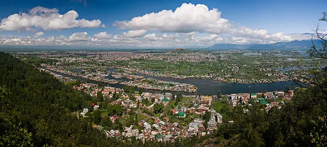
Srinagar is the largest city and the summer capital of the Indian state of Jammu and Kashmir. It lies in the Kashmir Valley on the banks of the Jhelum River, a tributary of the Indus, and Dal and Anchar lakes. The city is known for its natural environment, gardens, waterfronts and houseboats. It is also known for traditional Kashmiri handicrafts and dried fruits It is the northernmost city of India with over 1 million people.
Gulmargbaramulla, jammu_and_kashmir
Gulmarg is a town, a hill station, a popular skiing destination and a notified area committee in the Baramulla district of the Indian state of Jammu and Kashmir. The town is situated in the Pir Panjal Range in the western Himalayas.
Khilanmargsrinagar, jammu_and_kashmir
Khilanmarg, Jammu & Kashmir, India, is a small valley about 6 kilometres (3.7 mi) away from the Gulmarg. The meadow, carpeted with flowers in the spring, is the site for Gulmarg's winter ski runs and offers a view of the surrounding peaks and over the Kashmir Valley. It's a 600 metres (2,000 ft) ascent from Gulmarg to Khilanmarg. The view spans from the Himalayas from Nanga Parbat to the twin 7,100 metres (23,300 ft) peaks of Nun and Kun to the southeast.
Betaab Valleysrinagar, jammuandkashmir
Betaab valley is situated at a distance of 15 kilometers from Pahalgam in Anantnag district in India's northernmost state of Jammu and Kashmir. The valley got its name from the Sunny Deol-Amrita Singh hit debut film Betaab. The Valley is towards northeast of Pahalgam and falls between Pahalgam and Chandanwadi and is en route Amarnath Temple Yatra. The valley surrounded by lush green meadows, snow clad mountains and covered with dense vegetation. Betaab Valley, which is a part of Pahalgam area – one of the several Sub-valleys of Kashmir Valley came into existence during the post geosynclinal stage of the development of the Himalayas. Betaab Valley lies between the two Himalayan Ranges – Pir Panjal and Zanskar. Archaeological evidence proves the human existence in this region from the Neolithic Age, especially at Burzahom, Bomai and Pahalgam. Betaab Valley – a part of the Kashmir region, was ruled by the Mughals since the 15th Century. In latter part of the 15th century the Turko-Mughal Military General Mirza Muhammad Haidar Dughlat ruled over Kashmir first on behalf of Sultan Said Khan of Kashgar and then on behalf of the Mughal Emperor Humayun. A polyglot and a historical writer, General Haider wrote the ‘Tarik-i-Rashidi’ – a personal memoir of the Central Asian History.
Shikarasrinagar, jammu_and_kashmir
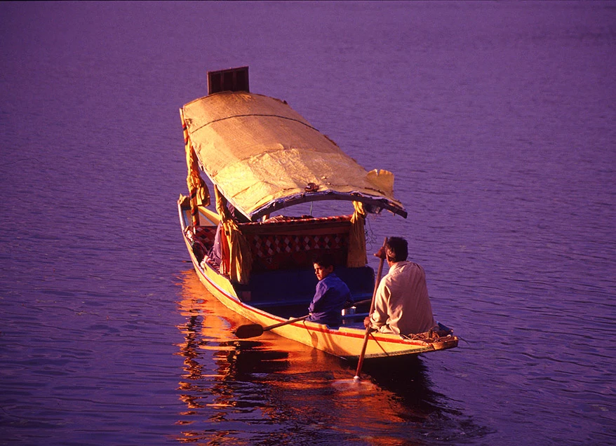
The shikara is a type of wooden boat found on Dal Lake and other water bodies of Srinagar in Jammu and Kashmir, India. Shikaras are of varied sizes and are used for multiple purposes, including transportation of people. A usual shikara seats half-a-dozen people, with the driver paddling at the rear. Like the Venetian gondolas, they are a cultural symbol of Kashmir. Some shikaras are still used for fishing, harvesting aquatic vegetation (usually for fodder), and transport, while most are covered with tarpaulins and are used by tourists. Some are used as floating homes by poor people. Shikaras at Dal Lake Shikara at sunset.